
Maryland’s Weekend Weather Outlook: Heat and Storms
Get ready, Maryland! Meteorologist Alina Lee has the latest on the weather forecast, and it’s a mixed bag of sunshine, heat, and the potential for some stormy weather. The live radar shows a relatively quiet scene for now, but that’s all set to change as we head into the weekend. This forecast covers everything from tonight through the early part of Sunday, so you know what to expect. Whether you’re planning outdoor activities or just trying to figure out your weekend schedule, this is what you need to know.
The primary focus of the forecast revolves around a shift towards potentially dangerous conditions. The main concerns are the development of afternoon thunderstorms on Sunday, and a heat wave building through the early part of the next week. The combination of high heat and humidity could make it feel like 100 to 105 degrees Fahrenheit in the area, with the chance for afternoon thunderstorms. With the potential for severe weather, it’s crucial to stay informed.
Tonight’s Forecast: Mostly Cloudy with a Chance of Storms
As we move through the night, the weather will be mostly cloudy, with a slight chance of an isolated shower or thunderstorm. Temperatures will hover around 75 degrees Fahrenheit. As the evening progresses, there’s a potential for some isolated thunderstorms to develop. As the night progresses into Sunday morning, the weather is expected to quiet down. Keep an eye on the radar and be prepared for any potential changes.
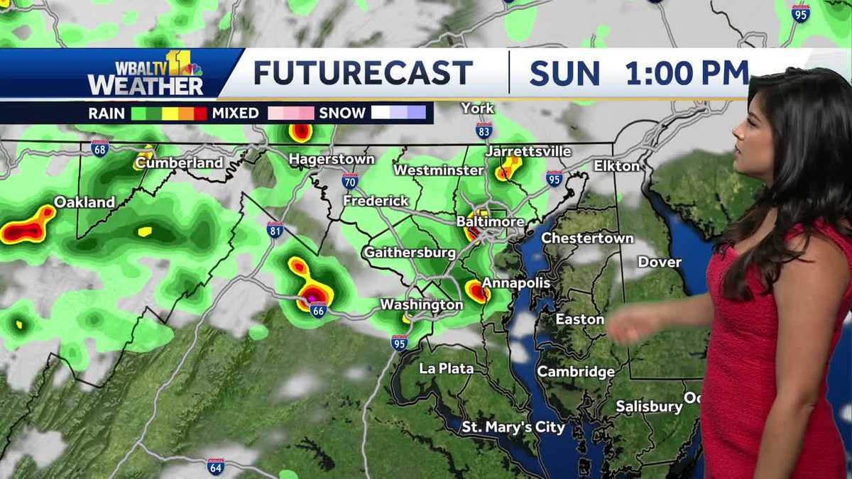
The early part of your Sunday is expected to be partly to mostly sunny. However, as the day progresses, especially around lunchtime (about 1:00 PM), the forecast suggests the possibility of a few thunderstorms developing. These storms are expected to be off and on, with chances increasing throughout the middle of the day. It’s essential to stay updated on any alerts or notifications related to severe thunderstorms, as damaging winds are a possibility.
Sunday’s Storms: Timing and Potential Impacts
The peak of the thunderstorm activity is expected to be in the middle of the day on Sunday, tapering off towards sunset. The greatest risk from any stronger or severe thunderstorms would be damaging winds. Other threats include frequent lightning and heavy rain. The timeframe to watch for potential thunderstorms is between lunchtime and 8:00 PM. Make sure you have ways to receive weather updates, such as alerts on your phone. It’s a good idea to have a plan in case any outdoor events need to be moved indoors.
During the middle of the day on Sunday, the weather pattern indicates a higher risk of isolated severe thunderstorms. If you are planning any outdoor activities during this time, it is important to remain informed, and be prepared for potential disruptions. Remember that while severe thunderstorms pose a threat, any thunderstorm can bring frequent lightning, heavy rain, and, of course, the potential for localized flooding.
The Heat Wave Arrives: Prepare for Dangerous Conditions
Beyond Sunday’s potential thunderstorms, a heat wave is on its way, with Monday’s dew points driving temperatures that will feel like 100 degrees Fahrenheit. The dangerous heat and humidity will peak on Tuesday and Wednesday, with feels-like temperatures likely between 105 to 110 degrees Fahrenheit. The high temperatures themselves will be closer to the triple digits. It is very important to take necessary precautions.
The weather forecast will change by Thursday because a cold front will move in, bringing a drop in high temperatures, as well as a chance for thunderstorms and lower humidity. This should bring a welcome respite from the heat. Remember to stay hydrated, wear appropriate clothing, and take breaks in air-conditioned spaces if possible.
Looking Ahead: Seven-Day Forecast
The seven-day forecast shows low to mid-90s on Sunday and Monday, with temperatures in the upper 90s on Tuesday and Wednesday. The good news is that the high temperatures will start to decrease, thanks to the arrival of a cold front, which also brings the chance for thunderstorms and reduced humidity. Prepare for a fluctuating weather pattern, and stay tuned for any updates.
This is your weather forecast for Maryland! Stay informed, stay safe, and be prepared for the heat and potential thunderstorms. Remember to keep up-to-date with any weather alerts and take necessary precautions. This includes the potential for severe weather on Sunday and the approaching heat wave next week. This is the weather update. Enjoy your weekend, and stay safe.